Government Grants
Business Grants
Home Owner Programs
Federal Programs
About Us
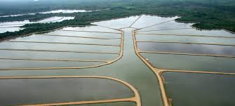
Geomorphic and Vegetation Mapping in the Mojave River Riparian Corridor
The goals of this agreement are to determine non-native plant evapotranspiration, and depth to groundwater along the Mojave River, California.
These goals will be accomplished through the acquisition and processing of high resolution short wave (green, red, and near-infrared) thermal infrared aerial digital photography, and LiDAR data collection for the Mojave River, California.
These data will be used to make multispectral mosaics, LiDAR point cloud data, a Digital Elevation Model (DEM), a thermal infrared mosaic of the floodplain corridor, energy balance estimates and evapotranspiration (ET) maps for the floodplain corridor, and a final report describing the data and methodology, main features of the imagery and LiDAR data, accuracy assessment of LiDAR data and seasonal estimates of ET.
The classification of vegetation using the multispectral imagery and the depth to the ground water estimates will be realized by the Bureau of Reclamations Regional GIS Center using the image and LiDAR products developed by USU.
Obtain Full Opportunity Text:
Not Available
Additional Information of Eligibility:
This is a NOI to award, no competition is being sought.
Full Opportunity Web Address:
Contact:
Shawna ThompsonGrants SpecialistPhone 702-293-8570
Agency Email Description:
smthompson@usbr.gov
Agency Email:
smthompson@usbr.gov
Date Posted:
2010-06-10
Application Due Date:
2010-06-24
Archive Date:
2010-07-24
Social Entrepreneurship
Spotlight
Black Country Social Enterprises Bag SEWM Awards

Social enterprise triumvirate from the Black Country were recognized as the main winners at the Social Enterprise West Midlands (SEWM)-backed event.
Learn How to Identify and Avoid Grant Scams
